

Welcome to the flexAEM Blog, a forum for prospective and experienced groundwater modelers, and those interested in learning more about AEM modeling using the flexAEM System!
Friday, June 29, 2018
New Exercises - Using AnAqSim with QGIS!
FlexAEM is pleased to announce the addition of a new set of exercises to the AnAqSim Instructional Series! The new set of exercises demonstrates the link between QGIS, a free and powerful open-source software package that can be used as a graphical interface for building and displaying model results, and AnAqSim. The series demonstrates how to digitize features and build basemaps in QGIS, and how AnAqSim model results can be viewed in 2D and 3D in QGIS. Check out the new instructional series HERE.


Wednesday, February 1, 2017
Updated Tutorial Packages and Pricing!
The flexAEM team is pleased to announce that we have updated
ALL of the tutorials in our AnAqSim Instructional Series to incorporate the many new enhancements and
improvements to AnAqSim; the innovative analytic element groundwater modeling
software from Fitts Geosolutions. Some of the recent enhancements and
improvements to AnAqSim include:
- A completely redesigned user interface with three tabbed windows for data input, run time messages, and display of model results
- New transient model features that allow you to save all time-step data to plot transient hydrographs and perform transient pathline tracing
- Modified data inputs for hydraulic features with conductance or resistance (leaky barrier, drain or fracture element, and head-dependent normal flux (3rd type) line element) to more closely match conductance and leakance terms familiar to engineers and hydrogeologists
- The ability to save, and then reload, AnAqSim model solutions so there is no need to re-run a time-consuming model file just to re-plot or analyze solution results
- Updated the data grid and results plotting components
- Enhanced model calibration tools and statistics
- New analysis tools for examining groundwater flux terms in transient simulations, and
- The addition of many pop-up menu items for faster model construction and analysis
To incorporate these new features, and make it easier for
new users to learn AnAqSim, we restructured our dozens of tutorials into
exercise sets that focus on specific modeling topics and features of AnAqSim. Our
current exercise sets include:
Set 1: Introduction to AnAqSim (using AnAqSimEDU)
Set 2: Adding heterogeneity; streams and rivers;
adding a trench and a conductive drain
Set 3: Adding sub-domains within a large model to
represent recharge or infiltration areas, ponds, and lagoons; joining streams
to lake features; adding a transmissive geologic fault
Set 4: Multi-layer aquifer modeling; multi-screen
wells; simulating stream, river and lake features in a multi-layer model
Set 5: Transient modeling including transient
hydrographs for a single pumping well, and working with saved time-step data
for hydrographs and transient pathline tracing; model calibration concepts and
tools; and adding geologic structure to the base of a model
Set 6: Graphical tools for building and analyzing
flow models including importing basemap files for model construction; advanced
pathline tracing methods; and use of View Manager features to create
report-ready graphics
Set 7: The power of linking the EnviroInsite
environmental data management and 3D visualization system with AnAqSim
including WMS (web sourced) digital maps for basemaps, creating basemaps in
EnviroInsite for import into AnAqSim, creating river and stream data sets for
import into AnAqSim, and display of AnAqSim model results in 2D and 3D
Set 8: Diving deeper into AnAqSim tools and features
including data grids, solver settings, digitizing tools, model inspector and
analysis tools, and exporting model results for post-processing
We are also currently working on Exercise Set 9, which
covers saltwater modeling in AnAqSim, including single-layer and multi-layer
saltwater interface modeling, saltwater upconing beneath pumping wells, lateral
saltwater intrusion modeling, and proper setting of coastal boundary conditions.
In addition to restructuring our tutorial sets, we have also
updated our pricing, including new bundles that
allow you to purchase our exercise sets at a significant discount!
Visit us on the web at www.flexAEM.com
to get started modeling with the flexAEM system today!
Monday, November 7, 2016
NEW! Updated FREE flexAEM Tutorials
The flexAEM team is happy to announce that we have released an updated set of FREE tutorials for users who want to explore the power of AnAqSim groundwater modeling software. To find out more, or to download the new tutorials, visit us at www.flexAEM.com.
So, what’s new in the updated tutorials you may ask? Here’s a little of the background:
There have been many new enhancements and improvements to AnAqSim analytic element groundwater modeling software in the second half of 2016, including:
You can read more about these exciting new updates to AnAqSim here: http://www.fittsgeosolutions.com/release-notes/
This new version of AnAqSimEDU allows you to perform some fairly sophisticated groundwater modeling.
So, the first thing we did was update our FREE set of flexAEM tutorials that provide an introduction to AnAqSim based on the free AnAqSimEDU software (downloadable from Fitts Geosolutions at http://www.fittsgeosolutions.com/downloads-licensing/)
Pair the Fitts Geosolutions Free AnAqSimEDU with our flexAEM free tutorials, and you are well on your way to learning groundwater modeling in a simple, powerful, analytic element modeling environment.
But we didn’t stop there. We are in the process of updating ALL of our tutorials to provide training on all of the new AnAqSim features noted above. To make it easier for new users to learn AnAqSim, we restructured our dozens of tutorials into exercise sets that focus on specific modeling topics and features of AnAqSim. Here is the list of exercise sets that we are currently working to update:
Set 1: Introduction to AnAqSim (using AnAqSimEDU)
Set 2: Adding heterogeneity; streams and rivers; adding a trench and a conductive drain
Set 3: Adding sub-domains within a large model to represent recharge or infiltration areas, ponds, and lagoons; joining streams to lake features; adding a transmissive geologic fault
Set 4: Multi-layer aquifer modeling; multi-screen wells; simulating stream, river and lake features in a multi-layer model
Set 5: Transient modeling including transient hydrographs for a single pumping well, and working with saved time-step data for hydrographs and transient pathline tracing; model calibration concepts and tools; and adding geologic structure to the base of a model
Set 6: Graphical tools for building and analyzing flow models including importing basemap files for model construction; advanced pathline tracing methods; and use of View Manager features to create report-ready graphics
Set 7: The power of linking the EnviroInsite environmental data management and 3D visualization system with AnAqSim including WMS (web sourced) digital maps for basemaps, creating basemaps in EnviroInsite for import into AnAqSim, creating river and stream data sets for import into AnAqSim, and display of AnAqSim model results in 2D and 3D
Set 8: Diving deeper into AnAqSim tools and features including data grids, solver settings, digitizing tools, model inspector and analysis tools, and exporting model results for post-processing
Set 9: Saltwater modeling in AnAqSim including single-layer and multi-layer saltwater interface modeling, saltwater upconing beneath pumping wells, lateral saltwater intrusion modeling, and proper setting of coastal boundary conditions
Updated tutorial sets will be available soon. Please check back here, or on our flexAEM website for announcements on release dates and special pricing!
So, what’s new in the updated tutorials you may ask? Here’s a little of the background:
There have been many new enhancements and improvements to AnAqSim analytic element groundwater modeling software in the second half of 2016, including:
- A completely redesigned user interface with three tabbed windows for data input, run time messages, and display of model results
- New transient model features that allow you to save all time-step data to plot transient hydrographs and perform transient pathline tracing
- Modified data inputs for hydraulic features with conductance or resistance (leaky barrier, drain or fracture element, and head-dependent normal flux (3rd type) line element) to more closely match conductance and leakance terms familiar to engineers and hydrogeologists
- The ability to save, and then reload, AnAqSim model solutions so there is no need to re-run a time-consuming model file just to re-plot or analyze solution results
- Updated the data grid and results plotting components
- Enhanced model calibration tools and statistics
- The addition of many pop-up menu items for faster model construction and analysis
- And many other new AnAqSim features
Plus,
- Fitts Geosolutions has changed AnAqSimEDU so it is no longer just a demo version of AnAqSim, but is essentially a free, standalone, powerful groundwater modeling software system. AnAqSimEDU now has the same capabilities as AnAqSim (groundwater flow, transient solutions, saltwater interface solutions, etc.), but is limited to 2 layers, 2 time periods, 5 steps/period, and 500 equations.
You can read more about these exciting new updates to AnAqSim here: http://www.fittsgeosolutions.com/release-notes/
This new version of AnAqSimEDU allows you to perform some fairly sophisticated groundwater modeling.
So, the first thing we did was update our FREE set of flexAEM tutorials that provide an introduction to AnAqSim based on the free AnAqSimEDU software (downloadable from Fitts Geosolutions at http://www.fittsgeosolutions.com/downloads-licensing/)
Pair the Fitts Geosolutions Free AnAqSimEDU with our flexAEM free tutorials, and you are well on your way to learning groundwater modeling in a simple, powerful, analytic element modeling environment.
But we didn’t stop there. We are in the process of updating ALL of our tutorials to provide training on all of the new AnAqSim features noted above. To make it easier for new users to learn AnAqSim, we restructured our dozens of tutorials into exercise sets that focus on specific modeling topics and features of AnAqSim. Here is the list of exercise sets that we are currently working to update:
Set 1: Introduction to AnAqSim (using AnAqSimEDU)
Set 2: Adding heterogeneity; streams and rivers; adding a trench and a conductive drain
Set 3: Adding sub-domains within a large model to represent recharge or infiltration areas, ponds, and lagoons; joining streams to lake features; adding a transmissive geologic fault
Set 4: Multi-layer aquifer modeling; multi-screen wells; simulating stream, river and lake features in a multi-layer model
Set 5: Transient modeling including transient hydrographs for a single pumping well, and working with saved time-step data for hydrographs and transient pathline tracing; model calibration concepts and tools; and adding geologic structure to the base of a model
Set 6: Graphical tools for building and analyzing flow models including importing basemap files for model construction; advanced pathline tracing methods; and use of View Manager features to create report-ready graphics
Set 7: The power of linking the EnviroInsite environmental data management and 3D visualization system with AnAqSim including WMS (web sourced) digital maps for basemaps, creating basemaps in EnviroInsite for import into AnAqSim, creating river and stream data sets for import into AnAqSim, and display of AnAqSim model results in 2D and 3D
Set 8: Diving deeper into AnAqSim tools and features including data grids, solver settings, digitizing tools, model inspector and analysis tools, and exporting model results for post-processing
Set 9: Saltwater modeling in AnAqSim including single-layer and multi-layer saltwater interface modeling, saltwater upconing beneath pumping wells, lateral saltwater intrusion modeling, and proper setting of coastal boundary conditions
Updated tutorial sets will be available soon. Please check back here, or on our flexAEM website for announcements on release dates and special pricing!
Friday, September 4, 2015
New AnAqSim Features and Updated Pricing!
Fitts Geosolutions recently released an updated version of
AnAqSim, the cutting-edge Analytic Element Method groundwater modeling software
package. This release incorporates many new features and makes AnAqSim more
powerful and even simpler to use. Some of the key changes include:
- Adding a new domain type
called “confined/unconfined” which switches from a confined domain to an
unconfined domain to simulate dewatering of an aquifer.
- Adding the ability to
execute automated runs from the command line, which allows for the
incorporation of parameter estimation programs like PEST.
- Increasing the maximum
number of layers from 10 to 14.
- Adding the ability to
change chart axis limits and intervals, make axes logarithmic, and save
graph images or data to files.
- Allowing transient
calibration targets.
- Adding the ability to export data (e.g. heads) that is the basis of
a contour plot as an ASCII x,y,z file
- And many other changes which make AnAqSim even more user friendly.

All of the flexAEM
tutorials and training
materials have been updated to incorporate these new features and teach you
everything you need to know about groundwater flow modeling with AnAqSim. And now, all flexAEM tutorials and tools are
available at a reduced price! Not only have we increased savings on each
flexAEM product, but the flexAEM team is excited to introduce the
new Ultimate Bundle Special, which includes ALL flexAEM tutorials, the flexAEM Model Feature Generator Toolkit,
and the AnAqSim Feature Focus series. All for just $100!
Our tutorials are great tools for modelers of all levels,
from beginner to expert. The flexAEM
Tutorial Series will teach you how to be an AnAqSim pro and you’ll learn some
great modeling tips and techniques which apply to any groundwater flow modeling
project. Visit
us on the web at www.flexAEM.com to get started modeling with the flexAEM system today! For the
full list of changes in the newest release of AnAqSim, visit the Fitts
Geosolutions website.
Wednesday, August 12, 2015
Check Out The New And Improved Remediation Calculator Toolkit!
The flexAEM Remediation
Calculator Toolkit has been revamped and now includes a 12th
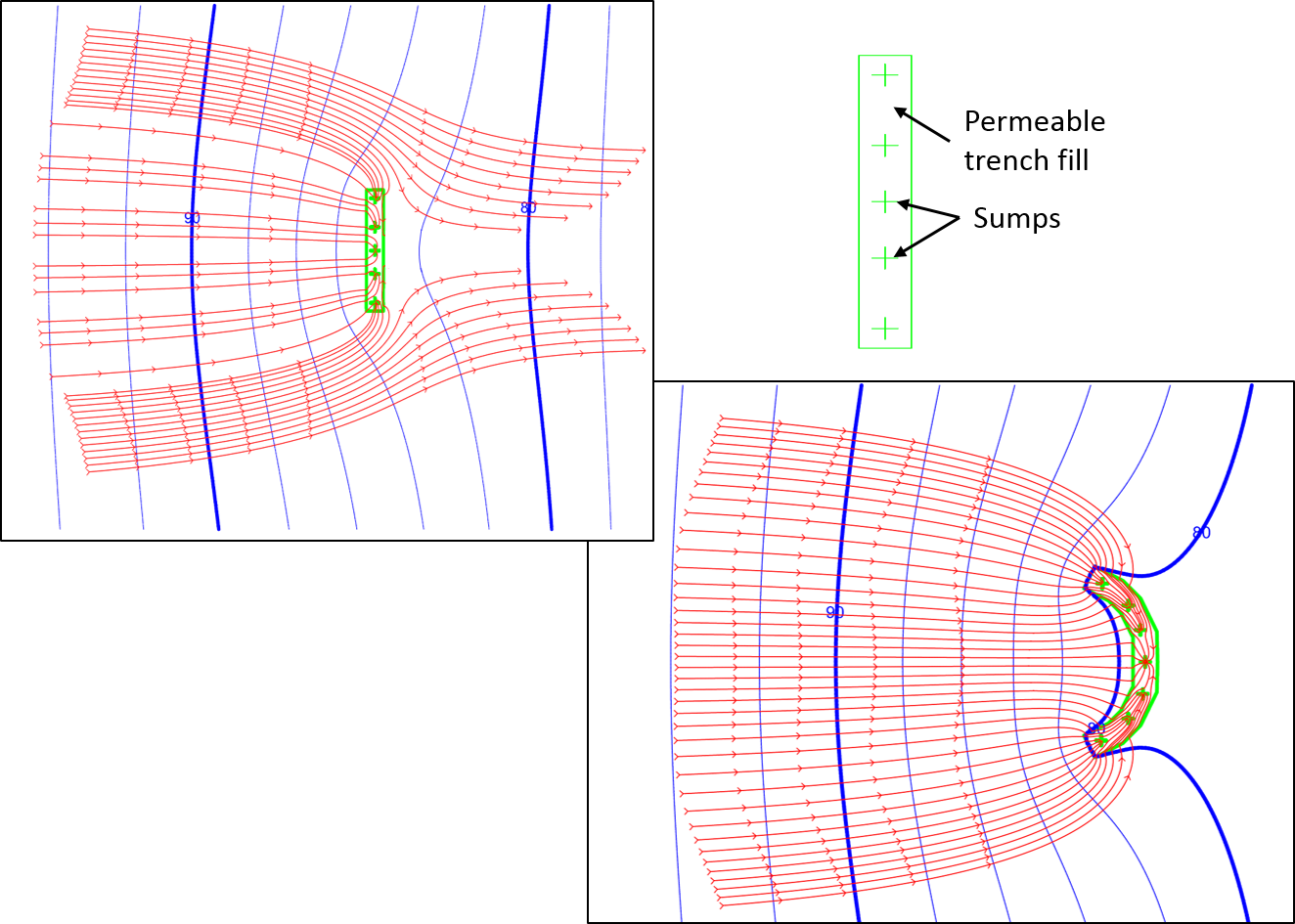
calculator for the design or optimization of a high permeability interceptor trench
containing multiple sumps. This new calculator provides a lot of flexibility
when considering a trench remediation design. Our original trench calculator was
designed to simply and quickly determine what extraction rate is required to maintain
heads in a trench. The new Interceptor Trench with Sumps calculator can be used
to perform a more detailed analysis of trench geometry, trench-fill material
properties, and sump locations. For example, the new calculator can help you
determine the permeability that will be required to maintain flow to the sumps,
the number of sumps needed and their optimal placement for differing lengths of
trench, and extraction rates required to maintain water levels in and around
the trench. The new calculator can be used to simulate a trench of any size or
shape, as shown below.
11 other great calculators are also included in the
Remediation Calculator Toolkit, which can be used to design and evaluate
groundwater extraction systems, vertical barrier and well systems, permeable
reactive barriers, and more. For more information feel free to Contact Us, or visit
the flexAEM website to learn more
about the Remediation Calculator Toolkit and download a free QuickStart Calculator Demo.
Wednesday, March 11, 2015
Uncover the Power of Multi-Layer AEM Models with the AnAqSim Instructional Series Advanced-1 Training Package
The Advanced-1 Training Package, which was recently added to
the AnAqSim Instructional Series, introduces an important new area of AnAqSim’s
capabilities: development of multiple layer groundwater flow models.
Unlike simpler AEM models, which generally only allow for
one model layer, AnAqSim can incorporate up to 10 model layers. Each layer can
have its own aquifer properties, its own hydraulic features (wells, line
sources and sinks, recharge or leakage areas, etc.), and its own boundary
conditions. This allows users to create
vertically-zoned aquifers, or vertical aquifer-aquitard sequences that can more
accurately represent geology within the aquifer domain and can simulate
three-dimensional groundwater flow conditions, such as vertical discharge to
surface water bodies or flow to partially penetrating features.
Similar in some ways to the new MODFLOW-USG software,
AnAqSim allows for flexible layering in a model – allowing more layers to be
added in an area of interest, and fewer layers in the far field area, as shown
below.

With this additional power and flexibility come some
additional requirements for model construction and testing to ensure an
accurate solution. The Advanced-1 Tutorial Series was designed to provide users
with detailed instruction on how to properly construct complex multi-layer
models, as well as tools and methods that should be utilized to analyze model
performance and evaluate aquifer response.
Topics covered include:
· When a multi-layer model may be necessary or
advantageous, and how to specify multiple layers in AnAqSim;
·
How and when extraction element basis points are
used to represent vertical leakage between layers;
·
Various methods for checking the accuracy of a
multi-layer model solution;
·
Tools and techniques for evaluation of 3-D
vertical flow conditions;
·
Proper assignment of model elements and
sub-domains to accurately represent hydraulic features;
·
How to identify and avoid errors when joining
model domains and model elements;
·
Adjustment of model settings to help improve
model convergence;
·
How to incorporate and accurately simulate flow
conditions within long, narrow domains (e.g. faults); and
·
Advanced pathline tracing techniques.
The concepts for properly constructing and testing a model are demonstrated in the tutorial series by constructing and examining simple, multi-layer models. The series begins with an overview lesson that explains the basic concepts and methods associated with the construction of multi-layer models in AnAqSim. The first tutorial exercise constructs a basic single-layer box model, and then adds multiple aquifer layers and a pumping well to demonstrate how the flow field changes as the model is transitioned from a single layer model with a fully penetrating well, to a multi-layer model with a fully penetrating lens, to a multi-layer model with pumping from a partially penetrating well. Pathline tracing is applied to examine the three-dimensional capture zone in the vicinity of the well screens. The importance of proper basis point spacing, as well as tools that can be utilized to analyze and test model performance, are also demonstrated.

The next set of exercises construct models to examine three-dimensional groundwater flow in a multi-layer area near a shallow river. These types of groundwater-surface water interaction models are often applied in ecosystem hydrology studies or conjunctive use water management studies. Multiple methods for representation of a river in an AnAqSim multi-layer model are explored (including the use of a line element within an aquifer domain, and a separate narrow domain with a head-dependent flux upper boundary condition), including how the depiction of vertical flow and discharge in the aquifer zone beneath the river is affected when employing each of these methods.

A set of exercises is also included that demonstrates the proper methods for joining an AnAqSim stream element to a lake or pond boundary. 2-D and 3-D models are constructed to explore the proper placement of stream and lake boundary control points. For the multi-layer model, the use of digitized polygon features to efficiently create more refined basis point spacing near surface water boundaries for greater model accuracy is also explored.

Finally, a model of a bedrock aquifer is created that incorporates a long, linear geologic fault feature with higher hydraulic conductivity. This transmissive fault model demonstrates the outstanding performance of a grid-free polyline-element modeling tool like AnAqSim in simulating small-scale high-resolution flow features that are oriented in ways that would be very difficult to design in a grid-based modeling system. The exercise demonstrates the proper techniques for designing these types of features, and employs pathline tracing to examine the effect of the fault on the groundwater flow patterns near the fault and in the vicinity of a nearby pumping well.

These tutorials should provide a great start in getting you
familiar with the concepts behind multi-layer AnAqSim model construction and
operation, for a variety of common three-dimensional model applications. They
cover the basic concepts, provide practical hands-on model building experience,
and teach valuable techniques for refining model design in key areas to improve
model solution accuracy.
Visit us on the flexAEM website to learn more about
the Advanced-1
Training Package and our other Tutorials and Tools today!
Tuesday, January 13, 2015
Introducing flexAEM’s Advanced Graphic Display Tutorials!
The flexAEM team is pleased to announce a new addition to our AnAqSim Instructional Series -- the Advanced Graphic Display Training Package!
This package of tutorials will show you how to get the most out of AnAqSim’s built-in graphics tools, which can give your model output a professional looking polish and help to better convey modeling results to colleagues and clients. The tutorials also demonstrate the link between AnAqSim and EnviroInsite, a powerful, low-cost software package that can be used as a graphical user interface for building and displaying AnAqSim models -- including the full interactive 3D display of AnAqSim pathlines and contours.


This package of tutorials will show you how to get the most out of AnAqSim’s built-in graphics tools, which can give your model output a professional looking polish and help to better convey modeling results to colleagues and clients. The tutorials also demonstrate the link between AnAqSim and EnviroInsite, a powerful, low-cost software package that can be used as a graphical user interface for building and displaying AnAqSim models -- including the full interactive 3D display of AnAqSim pathlines and contours.
Topics covered in the Advanced Graphic Display Training Package include:
• An overview of EnviroInsite environmental data visualization software
• Using basemaps and the AnAqSim View Manager features to enhance graphical display
• Use of basemaps in AnAqSim to guide model boundary and element digitizing
• Displaying model results over basemaps in AnAqSim
• Using EnviroInsite as a graphical pre- and post-processor to access web map services for basemaps
• Digitizing model features in EnviroInsite for import into AnAqSim
• Exporting two and three-dimensional AnAqSim model results to EnviroInsite for display and analysis
The Advanced Graphic Display Training Package includes two lessons, four high quality tutorials, all necessary modeling files, and all associated basemaps – everything you need to continue learning to model more complex hydrogeologic systems with AnAqSim!
For more information feel free to Contact Us, or visit the flexAEM website to learn more about the new Advanced Graphic Display tutorial set.
Subscribe to:
Posts (Atom)